Contact Seller
Graham Smith Antiques
Tel01661 852 122Please quote Antiques Atlas.

 1760 Miniature Road Map John Ogilby Stratford
 Antique Lithography Map, Lincolnshire, English
 Antique Lithography Map, Gloucestershire, English
 Antique Lithography Map, Northumberland, English,
 George IV Plan of North Shields & Tynemouth
 Blaeu Original Map of The Channel Islands, c.1659
 Antique Lithography Map, Worcestershire, English
 Antique Coaching Road Map, South Devon, English
 Antique Coach Road Map, East Devon, English
 Antique Lithography Map, Isle of Wight, English
 Antique Lithography Map, Cumbria, English, Framed
 Antique Lithography Map, Cornwall, English Framed
Non UK callers :
+44 1661 852 122
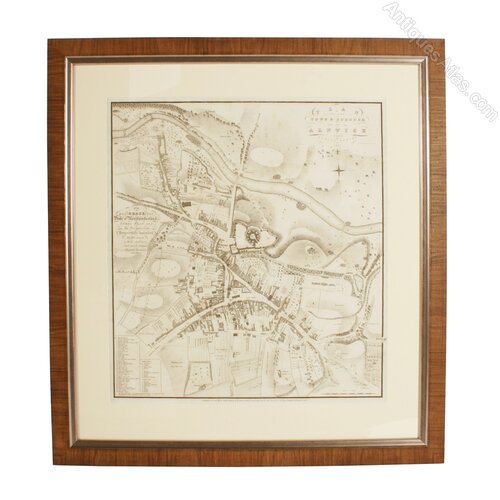
George IV Plan of Alnwick


An early 19th century George IV period plan of The Town & Borough of Alnwick by John Wood.
John Wood was born in Yorkshire around 1780-85, and he died in 1847. He is best known for his detailed plans of Scottish towns, but he produced town plans across England and Wales, his survey of Northumberland and Durham was between the years 1826-1827.
The map has an ackowledgement to the Duke of Northumberland "To his grace the Duke of Northumberland, this plan is by permission, respectively inscribed by his grace's most obedient and much obliged humble servant John Wood", if that did not get him some good 'brownie points' I don't know what will!
The plan is in very good condition and is held in a contemporary frame. (Circa 1827)
Height 83cm (32.7 inches)
Width 77.5cm (30.5 inches)
Depth 2.5cm (1 inch)
Please use the inquiry form to request further details of this item or make a purchase. Alternatively, call our shop and use the code 8539 to identify the item to us.++(0) 1661 852122.
SellerGraham Smith Antiques
View all stock from
Graham Smith Antiques

 Leadgate House
Horsley
Newcastle upon Tyne
North East England
NE15 0NT
Tel : 01661 852 122
Non UK callers : +44 1661 852 122
Get directions to Graham Smith Antiques
John Wood was born in Yorkshire around 1780-85, and he died in 1847. He is best known for his detailed plans of Scottish towns, but he produced town plans across England and Wales, his survey of Northumberland and Durham was between the years 1826-1827.
The map has an ackowledgement to the Duke of Northumberland "To his grace the Duke of Northumberland, this plan is by permission, respectively inscribed by his grace's most obedient and much obliged humble servant John Wood", if that did not get him some good 'brownie points' I don't know what will!
The plan is in very good condition and is held in a contemporary frame. (Circa 1827)
Height 83cm (32.7 inches)
Width 77.5cm (30.5 inches)
Depth 2.5cm (1 inch)
Please use the inquiry form to request further details of this item or make a purchase. Alternatively, call our shop and use the code 8539 to identify the item to us.++(0) 1661 852122.
Price
Arrange a final price and delivery details directly with the dealer
Click here to message the seller The price has been listed in British Pounds.
Conversion rates as of 24/APR/2024. Euro & Dollar prices will vary and should only be used as a guide.
Always confirm final price with dealer. This item has a level THREE shipping charge (£100 UK mainland)
Date Circa 1827
Early 19th Century Antiques Material Paper
Origin English
Item code as102a6292 / 8539
Status For Sale
£675.00 
$839.23
€785.23

$839.23

€785.23

Looking to Buy?
Payment with PayPal is availableArrange a final price and delivery details directly with the dealer
Click here to message the seller

Conversion rates as of 24/APR/2024. Euro & Dollar prices will vary and should only be used as a guide.
Always confirm final price with dealer. This item has a level THREE shipping charge (£100 UK mainland)
View all stock from
Graham Smith Antiques

 Leadgate House
Horsley
Newcastle upon Tyne
North East England
NE15 0NT
Tel : 01661 852 122
Non UK callers : +44 1661 852 122
Get directions to Graham Smith Antiques
You may also be interested in
 1760 Miniature Road Map John Ogilby Stratford
 Antique Lithography Map, Lincolnshire, English
 Antique Lithography Map, Gloucestershire, English
 Antique Lithography Map, Northumberland, English,
 George IV Plan of North Shields & Tynemouth
 Blaeu Original Map of The Channel Islands, c.1659
 Antique Lithography Map, Worcestershire, English
 Antique Coaching Road Map, South Devon, English
 Antique Coach Road Map, East Devon, English
 Antique Lithography Map, Isle of Wight, English
 Antique Lithography Map, Cumbria, English, Framed
 Antique Lithography Map, Cornwall, English Framed